1839 Samuel Augustus Mitchell Antique Map of New Holland, New Zealand & Oceania Discount
Description
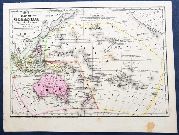
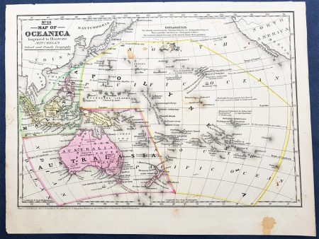
- Title : No 18 Map of Oceania…Entered according to Act of Congress in the year 1839 by S Augustus Mitchell
- Date : 1839
- Condition: (A) Very Good Condition
- Ref: 32148
- Size: 12in x 9in (305mm x 230mm)
Description:
This detailed original hand coloured copper-plate engraved antique map of New Holland – Australia, New Zealand, Polynesia & Micronesia, Oceania by Samuel Augustus Mitchell in 1839 – dated – was published in Mitchells School and Family GeographyGeneral Definitions:
Paper thickness and quality: – Heavy and stable
Paper color : – off white
Age of map color: – Original
Colors used: – Yellow, green, blue, pink
General color appearance: – Authentic
Paper size: – 12in x 9in (305mm x 230mm)
Plate size: – 12in x 9in (305mm x 230mm)
Margins: – Min 1 2in (12mm)Imperfections:
Margins: – Light soiling
Plate area: – Light soiling
Verso: – Light soilingBackground:
Early map of Australia and Oceania, the east coast is still referred to as NSW, with no sign of development of Melbourne or Victoria with New Zealand listing early Cook & Maori place names.
Additional Information
| Title | Default Title |
|---|